Spatial Planning
INSI provides a broad array of services tailored to meet the diverse needs of our clients.
Our expertise spans across the following sectors, ensuring that organizations can plan and develop sustainably and effectively by preparing the following vital services:
SPATIAL PLANNING

PREPARATION OF SPATIAL/URBAN PLANNING DOCUMENTS
INSI delivers comprehensive spatial development plans for municipalities, regions, and beyond, offering clear strategies for long-term growth. We specialize in preparation of Municipal Development Plans, Zoning Maps, and Regulatory Plans that cover essential aspects like infrastructure, economic development, social equity, and environmental protection to ensure balanced urban and rural development. Additionally, we also renowned for preparation of Regeneration or Master Plans for specific areas, focusing on revitalizing areas through sustainable solutions for urban renewal. These plans ensure both short-term adaptability and long-term sustainability for the regions we work with. INSI integrates global standards into our spatial planning services, ensuring compliance with international guidelines and regulations. Throughout our working experience, we have adopted EU Directives, such as (INSPIRE) Infrastructure for Spatial Information in Europe, HILUCS (Hierarchical Land Use Classification), and HSRLC “Hierarchy of Supplementary Regulation Code List”. These directives help us align our plans with global best practices, ensuring sustainable development, spatial data harmonization, and effective land-use management at municipal, regional, and broader levels. Our commitment to these standards enhances the quality and reliability of our urban and spatial planning projects.
INSI has the expertise, capacity, and experience to provide professional support for various spatial planning authorities throughout the preparation of the following mandatory spatial planning documents:
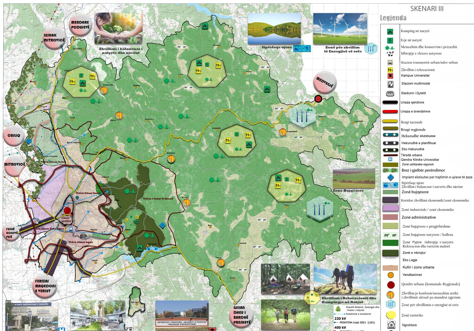
Development Plans - multi-sectoral strategic spatial planning documents, which set the long-term vision, objectives, and goals for future economic, environmental, natural disasters, cultural heritage, settlement, housing, land use, technical, transport, public, and social infrastructure spatial developments for urban and rural areas within the municipal territory.
Municipal Zoning Maps -multi-sectoral normative spatial planning documents, which establish long-term type, destination, planned spatial use, action measures, development conditions, and restrictions for the entire municipal territory, based on Municipal Development Plans and justifiable projections for public and private investments.
Regulatory Plans - multi-sectoral normative spatial planning documents, which establish detailed terms of constructions, as well as additional conditions for regulating spatial developments for specific urban or rural zones as defined in the Municipal Development Plan and Municipal Zoning Map.
INSI offers a full range of spatial planning services that ensure sustainable and strategic development for urban and rural areas. Our services are backed by deep expertise, advanced GIS technologies, and a thorough understanding of spatial dynamics. INSI offers comprehensive professional support in preparing essential spatial planning documents. Our expertise, capacity, and experience ensure the successful development of various strategic and normative documents crucial for effective urban and rural planning.
Municipal Development Plan
Key Spatial Planning Documents Prepared by INSI:
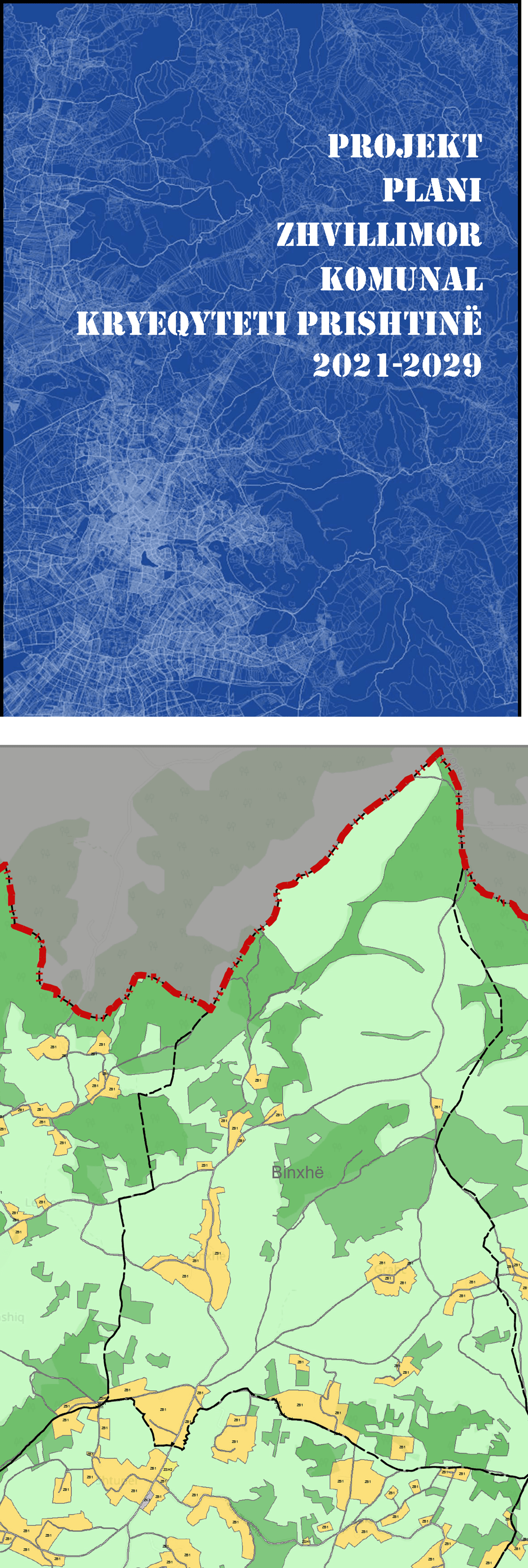
1. Municipal Development Plans (MDP)
Municipal Development Plans are multi-sectoral strategic frameworks that outline the long-term vision and objectives for economic, environmental, cultural, and social development within municipal territories. Each MDP consists of:
• Textual Section:
• Municipal Profile: Reflects existing conditions and assessments.
• SWOT Analysis: Identifies strengths, weaknesses, opportunities, and threats.
• Spatial Development Framework: Establishes vision, objectives, and goals.
• Strategic Development Priorities: Summarizes an actionable implementation plan.
• Action Plan: Provides detailed steps, resources, and timelines for achieving objectives, along with a cost-benefit analysis.
• Implementing and Monitoring Provisions: Ensures effective oversight of the plan's execution.
• Cartographic Section:
• Integrated maps on thematic areas, showcasing essential information for sectoral development.
• Includes maps for land use, economic development, transport infrastructure, utilities, and environmental protection.
Completed Municipal Development Plans -
1. Municipal Development Plan for Municipality of Obiliq;
2. Municipal Development Plan for Municipality of Suharekë;
3. Municipal Development Plan for Municipality of Mitrovica;
4. Municipal Development Plan for Municipality of Gjilan;
5. Municipal Development Plan for Municipality of Kamenica; and
6. Municipal Development Plan for Municipality of Ferizaj.
Ongoing Municipal Development Plans -
1. Municipal Development Plan for Municipality of Shtime;
2. Municipal Development Plan for Municipality of Vushtrri;
3. Municipal Development Plan for Municipality of Prizren;
4. Municipal Development Plan for Municipality of Fushe Kosove;
5. Municipal Development Plan for Municipality of Shterpce; and
6. Municipal Development Plan for Municipality of Lipjan.
Municipal Development Plan is a multi-sectoral strategic plan which sets municipal long-term goals of which set the long-term vision, objectives, and goals. Municipal Development Plan consists of the:
1. Textual Section; and2. Cartographic Section.
Textual Section The textual section of the Municipal Development Plan reflects the existing conditions and their assessment, upon which the future spatial development framework, strategic priorities, and implementation plan for future economic, environmental, natural disasters, cultural heritage, settlement, housing, land use, technical, transport, public, and social infrastructure is based. This section is composed of the following parts:
1. Municipal profile that reflects the existing conditions;
2. Assessment of the existing conditions based on SWOT analysis, trends, needs, projections, forecasts, and future assumptions that are relevant to the municipality;
3. Spatial Development Framework that establishes the vision, objectives, and goals;
4. Strategic Development Priorities that establish a summarised action plan;
5. Action Plan, which establishes a detailed action plan, including financial, human, and spatial resources necessary to achieve the objectives and plans, effectiveness and time frame, and cost-benefit analysis; and
6. Implementing and monitoring provisions.
The Cartographic part of the MDP - consists of integrated maps according to thematic areas for the entire municipal territory prepared in the official spatial planning system in a GIS platform, which presents essential information for all sectoral development plans as a result of the Spatial Development Concept and Strategic Development Priorities. These maps include but are not limited to the following: The planned spatial development map presents all existing and planned settlements with construction spaces and protection measures for development;
The planned land use map determines the future use of land for agricultural, residential, commercial, technological, industrial and mixed-use.
Maps of sectoral development plans, including planned spaces, constructions, and infrastructure with all aboveground and underground installations, as follows:
1. Economic Development Plan Map;
2. Transport Infrastructure Plan Map;
3. Urban and Rural Transport Plan Map;
4. Electricity and Thermal Energy Plan Map;
5. Water Supply and Sewerage Plan Map;
6. Irrigation and Drainage System Map;
7. Map of Telecommunication Plan and Related Installations;
8. Map of Public and Social Spaces;
9. Sports Space Plan Map; Public and Green Spatial Plan Map;
10. Cemetery Management Plan Map;
11. Map of the Plan for the Protection of Natural and Cultural Heritage;
12. Map of the Plan for Protection from Natural Hazards; and
13. Waste Management and Recycling Plan Map.
Municipal Zoning Map
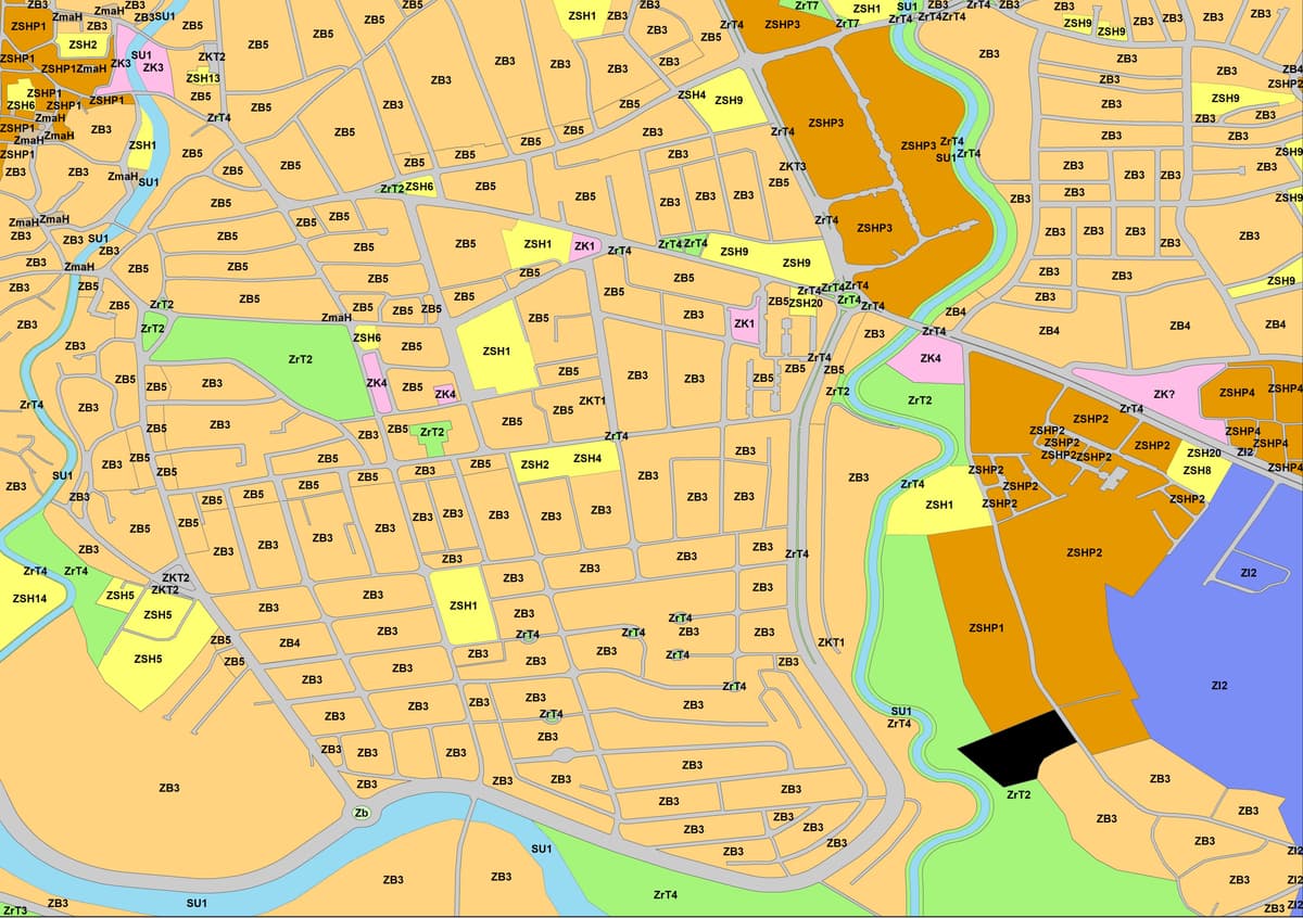
"INSI has the expertise, capacity and experience to provide support in the preparation of the Municipal Zoning Map as well - which is a multi-sectoral document using graphs, photos, maps and the textual part that precisely defines the type, destination, planned spatial use and action measures based on the duration and reasonable forecasts for public and private investments. for the entire territory of the municipality, for a period of at least eight (8) years; and containing the textual and cartographic part which are presented digitally and in printed formats for formal approval and signature. The textual part of the Zonal Map of the Municipality contains the development conditions and protection measures for all zones of the entire municipal territory, including the development of technical, public and social infrastructure, all in A4 format, with the following parts:List of zones and List of Superficial zones, Destined zones and development conditions including Construction conditions, Superficial zones and Development Conditions, Technical infrastructure, Road infrastructure, Public and social infrastructure, Justifying for the need to draft detailed planned regulatory plans, Implementation Action Plan, Administration, implementation and monitoring of implementation, Additional change and exceptions and Definitions.
Completion of Projects on Municipal Zoning Maps
1. Municipal Zoning Map of the Municipality of Gjakovë
2. Municipal Zoning Map of the Municipality of Suhareke
3. Provision of services for Zonal Maps and other professional services for the needs of MESP, Ministry of Environment and Spatial Planning
4. Municipal Zoning Map of the Municipality of Shtime
5. Municipal Zoning Map of the Municipality of Kline
6. Municipal Zoning Map of the Municipality of Fushe Kosove
Ongoing projects
7. Municipal Zoning Map of the Municipality of Vitia
8. Municipal Zoning Map of the Municipality of Obiliq
9. Municipal Zoning Map of the Municipality of Gracanice
10. Municipal Zoning Map of the Municipality of South Mitrovica
11. Municipal Zoning Map of the Municipality of Shterpce
12. Municipal Zoning Map of the Municipality of Gjilan
13. Municipal Zoning Map of the Municipality of Rahovec
14. Provision of services for Zonal Maps and other Professional Services for the needs of MESP, Ministry of Environment and Spatial Planning
15. Municipal Zoning Map of the Municipality of Ferizaj
The Cartographic part of the Zonal Map
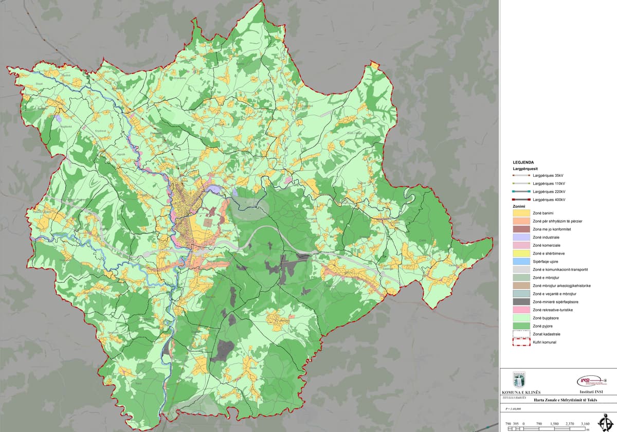
Of the Municipality consists of integrated maps according to thematic development areas of the entire municipal territory prepared in the official spatial planning system in a GIS platform, which provides essential information to explain to the public about land use opportunities. development conditions and protection measures. These maps include but are not limited to the following: General layers. The Zonal Map of the Municipality that is presented to the public should be based on the latest official cadastral maps, orthophotos, aerial maps and topographic maps. Depending on the specifics of the treated zones, the municipality can use other informative and classification maps that show the natural, morphological, hydrological, geological, geo-technical, seismic, climatic and other conditions to analyze the existing situation and create protection measures during development of the Zonal Map of the Municipality. The municipality will comply with the requirements of the Administrative Instruction on the Spatial Planning Database regarding the technical specifications of the maps. The municipality during the definition of areas analyzes and takes into account the following maps: Map of the location of existing settlements and planned extensions by the Municipal Development Plan, Map of planned land use from the Municipal Development Plan, Maps with existing areas and planned for economic activities, Maps with forest areas, surface and underground resources and protected water areas, Agricultural land use map, Map of forests and forest lands, Map of existing and planned areas for tourism, Map of areas for commercial, industrial and technological activities, Maps with Protected Areas, Special Areas, Special Protected Areas and Protected Areas, Maps with areas with natural, environmental and other hazards, AND Map with areas of informal settlements. (Presents the boundaries of the areas of informal settlements with the applicable development conditions).
Urban Regulatory, Regeneration & Master Plans
We specialize in Urban Regeneration, offering integrated solutions to revitalize areas with a social, economic, and environmental decline. These plans ensure sustainable improvements and align with broader development goals.
Urban Regulatory, Regeneration & Master Plans are detailed multi-sectoral normative documents that define the type and planned use of land across the municipality for a minimum of eight years. Each Zoning Map includes:
• Textual Part:
o List of Zones: Details all designated areas and their specific purposes.
o Development Conditions: Specifies construction and technical infrastructure requirements.
o Action Plans: Outlines implementation strategies, monitoring, and adjustments.
• Cartographic Part:
o Thematic maps detailing land use, development conditions, and protection measures
.
o Visual representations of infrastructure needs, including transportation, public services, and environmental safeguards.
Completed Regulatory Plans
1. Detailed Regulatory Plan “Economic Zone Gllavice”, Shtime;
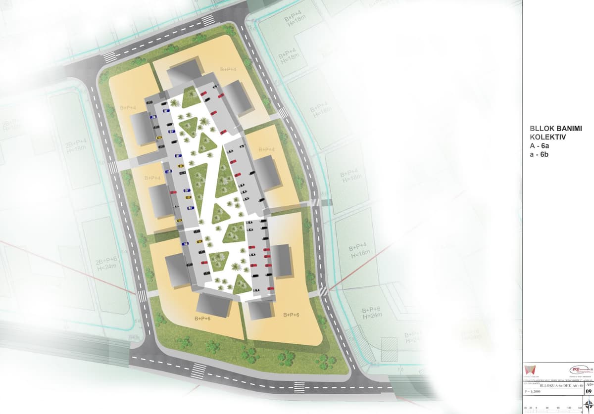
2. Detailed Regulatory Plan “Fidanishte 2”, Gjilan;
3. Detailed Regulatory Plan “Town Centre”, Drenas; and
4. Detailed Regulative Plans for 3rd Zones in National Park “Bjeshket e Nemuna”, Municipal Zoning Map of the Municipality of Shtime;
Ongoing Municipal Zoning Maps
5. Detailed Regulatory Plan “Industrial Park”, Prizren;
6. Detailed Regulatory Plan “Eastern Urban Area”, Drenas;
7. Detailed Regulatory Plan “Western Urban Area”, Drenas; and
8. Detailed Regulative Plans for 3rd Zones in National Park “Bjeshket e Nemuna”, Municipal Zoning Map of the Municipality of Shtime;
Geospatial Information Systems (GIS)
Our cutting-edge GIS solutions enable precise mapping, analysis, and data management. We assist clients with data visualization and spatial intelligence, supporting decision-making in urban planning, environmental management, and infrastructure development. From large-scale municipal projects to small enterprise needs, we ensure spatial accuracy and insight.